
GARMIN GPS 96C COLOR AVIATION GPSMAP PILOT AVIONICS 296 396 196 295 96 bundleClick here to purchase or contact the seller of this item on eBay |
|
|
| Current Price: 279.95 USD |
THIS GPS IS USED IN EXCELLENT CONDITION - ALL FUNCTIONS TESTED PERFECTLY
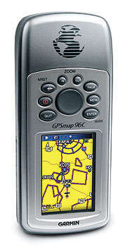
GPSMAP 96C
COLOR
Aviation Navigator
Garmin GPSMAP 96C (Americas)
The portable, color GPSMAP(R) 96C, along with GPSMAP 96, integrate
full-featured GPS navigation with a Jeppesen database and comprehensive
towers-and-obstacles database — giving pilots the freedom to go anywhere.
The pilot-friendly GPSMAP 96C has a crisp color display, making map detail easy
to read. With 119 megabytes of memory and a mini-USB port, users can quickly
download and store map data from a variety of optional MapSource CD-ROMs. Its
simple one-thumb keypad control literally puts the world of GPS capability in
the palm of your hand.
Whether on land, sea, or air, the GPSMAP 96C is the smart, versatile way to get
there:
Extensive Jeppesen database includes airports, identifiers and services
Comprehensive U.S. database of obstacles and towers helps alert pilots of
potential hazards
Graphic HSI steering cues with GPS-derived VNAV provide added orientation
Built-in autoroute basemap and optional MapSource marine, topo and city street
mapping downloads let you move seamlessly from plane to car to boat to hiking
boots.
The GPSMAP 96C offers an extensive Jeppesen database along with a U.S. database
of obstacles for the ultimate in moving-map situational awareness. It depicts
Jeppesen(R) airport data overlaid on an electronic map, localizer-like runway
extensions, a GPS-derived horizontal situation indicator (HSI) and information
on nearby airports (including identifier, bearing and distance to each). It also
features a detailed database of nearby obstructions like radio towers and
high-rise buildings. Using symbology, it depicts an obstacle along the flight
route, giving pilots a visual cue and alerting them to potential hazards ahead.
An automatic logbook also calculates your flight time and automatically records
departure and arrival locations. When used with Garmin's free logbook software—FlightBook—this
feature makes light work of maintaining your logbook. Your flight information
will be stored in the unit and can be downloaded to this exclusive Flightbook
software at any time.
Like all of Garmin's new aviation portables, the GPSMAP 96C also provides
advanced navigation capabilities on the road or water. It features a built-in
basemap depicting highways, major roads, lakes, rivers, railroads and state and
national borders. It also provides automatic-route generation, off-route
recalculation, and turn-by-turn directions with audible tones to alert the
driver of upcoming turns.
When coupled with optional MapSource City Select(R) software, GPSMAP 96C enables
the user to locate and route to more than 5 million points of interest,
including hotels, restaurants, service stations, ATMs and more. For pilots who
also like to captain a boat, these units have a Marine mode. Using optional
MapSource BlueChart(R) or Recreational Lakes with Fishing Hot Spots(R) software,
users can navigate the high seas or nearby lakes with ease. An added bonus: The
GPSMAP 96C is not only waterproof, but also floats!
The GPSMAP 96C: One nav fits all.
GPSMAP 96C features:
- Unit dimensions: 2.7"W x 6.2"H x 1.4"D
- Weight: 7 ounces
- Display size: 2.6" diagonally
- Display resolution: 160x240-pixel, 256-color TFT display
- Usable storage capacity: 119 MB
- Battery life: Up to 40 hours in battery save mode, depending on backlight setting
- Antenna: Quad-helix
- WAAS capability: WAAS GPS receiver for enhanced lateral/vertical guidance
- Multi-platform navigation: Easy navigation in an aircraft, vehicle or boat and as a handheld GPS unit; accepts data from Garmin's MapSource CD-ROM products
- Waterproof: IEC 60529 IPX7 standards (submersible in one meter of water for up to 30 mins.)
- Routes, Tracks, Waypoints: 50 reversible routes (300 waypoints each), 20
saved tracks (500 trackpoints each), TracBack(R) technology and 1,000
waypoints with graphical icon identification
Additional specifications
HERE IS WHAT YOU GET
- GARMIN GPSMAP 96C
- CIGARETTE LIGHTER POWER CABLE
- USB DATA CABLE
- RAM YOKE MOUNT
- PILOT'S GUIDE (COMPLETE MANUAL)
Here is what some of our customers are saying
- Quick answer and item correspond to description! Thanks
- Item as described, in very good condition. Exellent seller!!!
- Fast shipping. Everything just as described. I recommend this one!
- item as described no problems quick shipping
- Items in good condition and packaged well, discription spot on, good service
- Item as listed and in good order, packaged well, execellent service
On Jul-07-08 at 04:13:29 PDT, seller added the following information:

|
Click here to purchase or contact the seller of this item on eBay