new and used avionics
 Sell Your Avionics Here
|
Avionics List
new and used avionics |
Sell Your Avionics Here
|
Buying Safety Tips |
Avionics Articles and Reviews
|
The AirMap 1000
Lowrance introduced the AirMap 1000 shortly after
Christmas 2004, too late to make the December sales.
I had talked about the AirMap 1000 on our website and many
Lowrance buyers were excited about receiving the GPS in their Christmas
stocking but it just wasn't meant to be.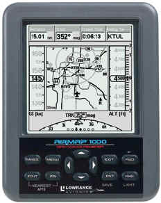 My early thoughts on the 1000 were that it was just a big AirMap
500; this would be good, I could use the same data from the 500 for the
AirMap 1000 to write this "Review'.
But I soon found after using the AirMap 1000 that there were
quite a few differences between the two models, not only size but
features also.
Now I've got to write a complete 'Review' but I learned a
lot over the last month using the AirMap 1000 in the air and in the
automotive mode.
My early thoughts on the 1000 were that it was just a big AirMap
500; this would be good, I could use the same data from the 500 for the
AirMap 1000 to write this "Review'.
But I soon found after using the AirMap 1000 that there were
quite a few differences between the two models, not only size but
features also.
Now I've got to write a complete 'Review' but I learned a
lot over the last month using the AirMap 1000 in the air and in the
automotive mode.
First, lets talk about what the AirMap 1000 is, the
size and capabilities. The
screen is nothing less than huge! The
16-level grayscale screen is a 5' diagonal high contrast Film
SuperTwist LCD. What that
really means is, the screen is big, highly defined and views great under
just about any lighting condition.
The screen loves direct sunlight, the more the better.
Under low light conditions, the white LED backlighting is more
than ample. The keys on the
keypad are backlighted also and look great at night.
The intensity of backlighting and the length of time the
backlighting is to remain on is user defined.
If you can't read an AirMap 1000 screen, then you've got some
serious problems, visit your local eye doctor.
Screen resolution is 320 pixels X 320 pixels resolution for a
total of 102,400 pixels. I
really don't know much about pixels but I do know the screen on this
giant is big and easy to pick items placed on it.
The 12 parallel channel receiver is hot; the unit receives WAAS
correction signals also. This
GPS contains a built-in antenna and comes with a remote, external
antenna also. There will be
times when the external antenna is needed.
The size of the case is 6.25' tall, 4.9' wide and 2.5'
deep.
This GPS will be hard
to lose because of its size. Oh,
the case is water resistant just in case you use it on the family yacht.
One of the nice features of this unit is the
removable MMC or SD memory card. The
owner can download custom maps from the supplied MapCreate 6, upgrade
operating system software and transferring trip data to your personal
PC. A USB card reader is
included. 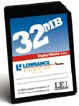 You can easily
record your GPS trips to this card.
Another nice feature is you can purchase these cards just about
anywhere, thus you don't have to pay the 'aviation price'.
The supplied card also contains the Jepps database for the
Americas. Airspaces, airports, NDB's intersections, Lowrance
Obstructions database, it's all on the card and ready for to use. Up
to 512MB can be stored on one MMC or SD card.
You can easily
record your GPS trips to this card.
Another nice feature is you can purchase these cards just about
anywhere, thus you don't have to pay the 'aviation price'.
The supplied card also contains the Jepps database for the
Americas. Airspaces, airports, NDB's intersections, Lowrance
Obstructions database, it's all on the card and ready for to use. Up
to 512MB can be stored on one MMC or SD card.
The unit updates once every second just like the
panel mounts (except the CNX80) or you can reduce the update rate to
increase battery life. Up
to 10 routes can be saved at 100 waypoints per route.
100 Plot Trails (whatever that is) with up to 10,000 points per
trail can be saved. Background
mapping is excellent (mapping stored inside the unit).
Built-in custom, detailed Lowrance map contain low-detail maps of
the while world. They
contain cities, major lakes, major rivers and political boundaries.
Medium-detail of the Continental is excellent and if you want
detail for an area, simply download it from the MapCreate CD to the
supplied data card. If you
are only using the AirMap 1000 for aviation, the supplied CD is not
needed. All the
ground mapping you'll ever need is already inside the GPS.
One COM serial port is built in the unit and is compatible with
NMEA 0183, version 2 for you guys who may want to tie the AirMap 1000
into another device.
DC Power. The
unit holds four AA batteries, I highly recommend using only alkaline
batteries. I found my
AirMap would run about 10 hours on four Costco AA's if I didn't use
the back lighting. Expect
12 hours or more with some alkaline batteries.
A cigar power cable is supplied and will work in 12 or 24Vdc
aircraft. Be advised, do NOT cut off the cable and pick up power from
under the instrument panel. IT
WILL smoke the unit and sadden your day, guaranteed. 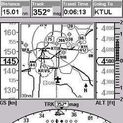 See, there is a voltage regulator built within the cigar lighter
cable that reduces the voltage down and when you whack off the end of
the cable, you're removing the regulator; thus 'Puff the Magic
Dragon' will appear and torch your Lowrance GPS.
As one would guess, that voids the warranty.
The book mentions this issue but chances are you will not read
the book before fiddling around with the unit.
See, there is a voltage regulator built within the cigar lighter
cable that reduces the voltage down and when you whack off the end of
the cable, you're removing the regulator; thus 'Puff the Magic
Dragon' will appear and torch your Lowrance GPS.
As one would guess, that voids the warranty.
The book mentions this issue but chances are you will not read
the book before fiddling around with the unit.
Speaking of the manual'Just like the AirMap 500,
the 1000's manual is written in terms pilots understand.
In fact, from what I heard, Lowrance hired a 'real' pilot to
write the manual and he/she did an excellent job.
To be honest, the AirMap 1000 is so easy to operate that the
manual is only needed when you venture into an area seldom used such as
some of the hiking areas or changing the update rate.
I'm SO GLAD Lowrance finally got someone other than engineers
to write their Operator's Guide.
The old AirMap 100/300 manual was a nightmare but those days are
gone. The back of the
manual has an excellent 'Index' section with just about anything one
could desire mentioned there and the Table of Contents located in the
front of the book is easy to understand.
For pilots like me that are 'kind of thick between the ears',
there's plenty of pictures in the manual and the print is large.
Packaging. When
you shake the AirMap 1000 package, it sounds to have as much play inside
as a BB in a boxcar. The
manual, accessories and everything but the GPS is just thrown in the
box. The GPS is secured quite well.
True, we've never had anyone complain about the equipment
rattling around in the box or experienced any damage of the accessories
but I have had a few phone calls asking me if we opened the box and had
the equipment out. In other
words, was the unit the received a used one.
No is the answer but I wish Lowrance would do a little better job
on packaging the accessories in the box.
If my shipping department packaged boxes that rattled; they would
be looking for work elsewhere. Lets
face it, the Lowrance AirMap is one of the best portables made today
(and probably the best within its price range) 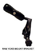 but the shoddy packing
just doesn't reflect well on the product.
Maybe Lowrance wanted me to find something early to gripe about
so I would get it out of my system'
but the shoddy packing
just doesn't reflect well on the product.
Maybe Lowrance wanted me to find something early to gripe about
so I would get it out of my system'
The AirMap 1000 comes with two RAM mounting
brackets. One is called a
'Yoke Mount' for our flying machines.
This mount is great and works in anything but a Beechcraft with
the thick yoke. Cessna, Mooney and Pipers guys shouldn't have a problem
mounting the 1000 to the yoke.
The automotive mount has a large suction cup on the bottom.
You need a flat, smooth surface to utilize this mount.
The blasted thing wouldn't work anywhere in any of my vehicles.
I ended up taping the remote antenna to the top of the dash and
laying the 1000 between the seats.
You'll find a way to mount it in your automobile if you really
intend to use it while driving. Depending
on the aircraft and day, you may need to use the external antenna.
The unit comes with the following standard
accessories:
Let's talk about the 'Key Pad'. The keypad consists of 12 keys that are marked as to their
function. I'll mainly
discuss the 'Aviation' functions during this time frame but the land
and marine modes are much like the aviation.
By the way, the keys on the AirMap have a nice solid feel to
them, you have no doubt if the key was pressed or not.
The PWR Key applies power to the unit and turns on
the backlighting. Backlighting
level is set in one of the menu pages. 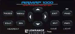 To turn the unit off, simply press and hold the 'PWR' key for
a couple of seconds and the screen goes blank.
Backlighting is available after the AirMap has been on for a few
seconds. Press the
'PWR" key on the unit and the backlighting will automatically
turn on also
To turn the unit off, simply press and hold the 'PWR' key for
a couple of seconds and the screen goes blank.
Backlighting is available after the AirMap has been on for a few
seconds. Press the
'PWR" key on the unit and the backlighting will automatically
turn on also
Pages. By
pressing this key you can toggle between the three page screens.
You'll use the 'Pages' key often and we will discuss its
features later. Lowrance
went out of their way to place the keys most used at the corners, making
it easy for the operators to find the key without looking.
Menu. Just
about every page has one or more menus.
Keep pressing the 'Menu' key and you'll dig deep into the
bowels of the 1000. Ready
to get back to pages screen again?
Simple, just press the 'Exit' key.
We will talk more about the menu functions later.
The Arrow Keys are used to navigate on pages, menus
and move the cursor. You
will also use this key to enter data such as airport ID and sorts.
The unit responds fast to Arrow Key entries due to the fast
processor within the AirMap 1000. Believe
me, you won't have to wait for a charter to show up when you press the
Arrow Key, unlike some of the older portable GPS's.
Ent/Save Key.
Use this key to save or accept data and execute commands. User defined waypoints can be created using this key.
It's strategically located on the 1000 and you'll use it
often.
Exit Key. Ah,
the good ole Exit Key is a savior.
Got into something you don't know the way out of?
Well, you're in luck, just press the 'Exit' key and
you're back to the main page you were on prior to getting in over your
head. If you change
something on a Menu page, just press 'Exit' after words to get out
of the menu. The 'Exit' key is your friend; get to know it.
FIND/Direct Key.
The Key says 'Find' with the aviation direct symbol above it.
If you are in the aviation mode you can choose direct to just
about anything; your predetermined destination, VOR's, Airports, you
name it, the AirMap 1000 has it available at your finger tips.
If you are in the Land Mode of operation, items such as highway
exits, streets, user defined waypoints and addresses will be your
choices.
Zoom In and Out.
There are two keys, one expands the area shown on the map, thus
less detail would be displayed; the reverse is true if you zoom in.
You can zoom all the way until the map is .03 miles or zoom out
until the map covers 4,000 miles. I found during my test the 20-50 mile
scales worked best in the aviation mode and 3-10 miles in the ground
mode.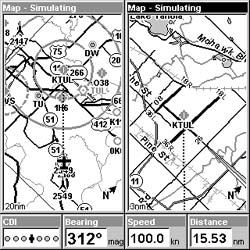 You'll use the
higher zoom values if you are panning out to an area not close by.
Oh, press both the 'Zout' and 'Zin' at the same time and
you'll get a list showing the nearest 40 or so airports, with the
closest being at the top. Move
the cursor up or down with the 'Arrows' key to highlight any
airport. The distance and
bearing is constantly displayed showing any airport within the list and
the longest runway is shown at the bottom of the list for the airport
selected. Yes, finding the nearest airport is as easy a pushing a
couple of buttons (at the same time). If you
think that was easy, the next feature will really excite you.
Lets say you have determined which airport you wish to fly to and
want to go there; all you have to do is highlight that airport and press
the 'Direct To' key and away you go!
Some portable GPS's require a lot of keystrokes to fly to an
airport within the 'Nearest' category but not the AirMap 1000.
Normally if you are using the Nearest Airport feature things
aren't going very well in the cockpit.
Lowrance makes navigating to the selected nearest a snap.
In my opinion, the AirMap 1000's Nearest Search feature is
a cut above the other manufacturers out there.
One can easily tell a pilot had some input on this feature, not
the Dilbert engineer.
You'll use the
higher zoom values if you are panning out to an area not close by.
Oh, press both the 'Zout' and 'Zin' at the same time and
you'll get a list showing the nearest 40 or so airports, with the
closest being at the top. Move
the cursor up or down with the 'Arrows' key to highlight any
airport. The distance and
bearing is constantly displayed showing any airport within the list and
the longest runway is shown at the bottom of the list for the airport
selected. Yes, finding the nearest airport is as easy a pushing a
couple of buttons (at the same time). If you
think that was easy, the next feature will really excite you.
Lets say you have determined which airport you wish to fly to and
want to go there; all you have to do is highlight that airport and press
the 'Direct To' key and away you go!
Some portable GPS's require a lot of keystrokes to fly to an
airport within the 'Nearest' category but not the AirMap 1000.
Normally if you are using the Nearest Airport feature things
aren't going very well in the cockpit.
Lowrance makes navigating to the selected nearest a snap.
In my opinion, the AirMap 1000's Nearest Search feature is
a cut above the other manufacturers out there.
One can easily tell a pilot had some input on this feature, not
the Dilbert engineer.
Let's talk Menus.
One powerful feature of the AirMap 1000 it the vast menus built
within. Not only is this
unit customizable via menus, the menus are very easy to use.
Go to any one of the three Main Pages and press the 'Menu'
key once. You will now see
a host of features that pertain to that particular page that are
available for use. Press
the 'Menu' key again and you'll visit the 'Main Menu' page,
you'll find all kinds of neat fun-to-do things within the menus.
Continue pressing the 'Menu' key and you'll toggle between the
menus for that page and the 'Main Menu'. The Main Menu page consists
of screen, sound, alarm and many more areas that can be tweaked to suite
your needs. The 'Sound'
selection may be OK in a quiet car but in an aircraft with a 94dB cabin,
you'll never the audio warning. I
encourage you to play around with the Menus, there's a lot you can
learn and you'll soon be setting the AirMap 1000 up to suit your
needs. I do wish Lowrance
had a 'Factory Default' setting (if it's there I couldn't find
it), this would allow you
to return the unit to the configuration it was set at when you received
it. Another powerful
feature is the GPS simulator mode.
One can give the GPS a speed and fly the trip while setting in
the comfort of your home. If
you can't figure out how to get out of the simulator mode (it's very
easy though), simply shut the unit off and the next time you turn it on,
it's back in the normal operating mode.
You want timers, the AirMap 1000 has them; count up, down or an
alarm clock, the choices are yours.
The Trip Calculator is way too cool.
For any given trip one can view the status of that trip such as
time, distance, max speed and a host of other goodies.
To date, I have used my AirMap 1000 for 2080.65 miles. The
trigger speed (speed at which the unit starts keeping a record) is
defined by the user, mine is set for 5 MPH.
I've touched on about 10% of the menu features here; the AirMap
1000 is full of easy to use features and I'd recommend you take the
time to learn them.
The Three Main Pages, Status, Navigation and Map
are the crown jewels are what makes this unit so easy to operate.
If you're in the Aviation mode, simply press the 'Pages'
key; you'll see a horizontal menu that says Status, Navigation, Map.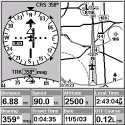 With the 'Arrows Keys' move the highlighter to the section you want
to be in and then press the 'Ent' key. Lets say you were on the
'Status Page' but had a desire to travel over to the 'Map Page'.
Simple, all you do is highlight over to MAP which will then
become highlighted. Notice
that options are now displayed on the screen below the word Map. From here you can select the page within that page you desire
to be displayed. What's
really nice about this feature is once you pick the page you desire, you
don't have to move the cursor up and down within that page to
highlight it again unless you wish to go to a different page.
With the 'Arrows Keys' move the highlighter to the section you want
to be in and then press the 'Ent' key. Lets say you were on the
'Status Page' but had a desire to travel over to the 'Map Page'.
Simple, all you do is highlight over to MAP which will then
become highlighted. Notice
that options are now displayed on the screen below the word Map. From here you can select the page within that page you desire
to be displayed. What's
really nice about this feature is once you pick the page you desire, you
don't have to move the cursor up and down within that page to
highlight it again unless you wish to go to a different page.
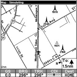
Under the 'Map Page' one can view the Map
Panel, Full Map, Compass Overlay, Digital Data and a page with two maps
shown. Lets discuss these pages.
Within this section the most useful is the Map Panel page in my
opinion. In the center of
the page is a nice moving map that one can alter the scale at anytime.
To the left is a bar graph just like you would find in modern
large aircraft that displays the ground speed.
I was amazed how easy it was to nail a speed using this feature.
To the right is your MSL altitude in one-foot increments.
Full right shows your vertical speed and at the top of the screen
are four user defined data fields.
The bottom of this page shows a partial HSI and an electronic CDI.
If you don't like the data fields displayed on this page, no
problem. Just like most
other pages shown on the AirMap 1000, simply go to the menu page and
change them to suit your needs. The
'Full Map' page is just that, it gives you a huge map with aviation
and ground data. At the
bottom of this page are five programmable fields for data you may want
to see such as groundspeed, bearing and sorts. The Compass Overlay page is really cool.
You'll see a huge map with a compass located at the top of the
page along with some small data fields.
A small CDI is located in the middle of the page.
Now that I've used this page for a couple of flights, I've
grown to really like it; chances are you'll use it often.
The Digital Data page shows seven user-defined data fields on the
far left of the screen and a moving map on the right side.
The map on the left side of the big screen can be scaled by the
user; the one on the right scales automatically to keep your present
position and destination on the screen.
There are four data fields at the bottom of this page.
In summary, the 'Map Page' has four sub-pages and can be
customized to suit your wildest desires.
The Navigation Page.
Many of you will drool over the 'Navigation Page', it's
much like one of the map pages. The
first 'Navigation Page' is what Lowrance calls Navigation Panel.
It's basically like the Map Panel page described above but with
a real looking HSI in the center. The
HSI has a small window that shows course deviation.
If you don't care to look at a moving map, then this is the
page to be. The second page
under the Navigation Page is called 'Navigation With Map' On this
page the HSI is placed in the top, left corner of the screen and a
moving map is placed in the top right corner.
At the bottom of the screen are eight data fields.
One thing that is really nice about this monster-size screen is
you sure can put a lot of 'stuff' on them and still figure out
what's going on. 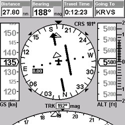 Only on the AirMap 1000 could you display so much data.
The Status Page will tell the pilot what signals
the unit is receiving and the levels of those signals.
Date, local time, energy level (if using batteries) and a host of
other data fields are located on the 'Status Page'.
There is only one page in the Status section. Oh, The AirMap 1000 can be set to alarm the owner anytime
WAAS isn't available and sure enough it works.
I've found in the KSMX area, WAAS is only available about 95%
of the time. Why you ask?
I really haven't a clue but it's nice knowing when WAAS is
down and only Lowrance has this feature.
Lets Go Flying!
The best thing about the AirMap 1000 is flying with the thing.
It has a huge screen and old pilots like myself will really
appreciate that. All I had
to do was glance at, not stare to find the info I was looking for.
To my surprise, the big 1000 didn't cover the panel instruments
anymore than smaller portable GPS's.
The mount allows it to be placed over the center of the yoke,
thus allowing good view of the panel instruments.
Take a look at the shots here and you'll see what I mean.
As mentioned earlier, this mount will not work in older center
column Beechcrafts. My
first flight was in the local area just to get used to the big 1000.
In the Piper I was flying that day, I had to use the supplied
external antenna and lay the antenna on the glare shield.
I've found over the years that some days the external antenna
is required with all portables but some days you can get by with the
built-in antenna. Normally
you'll get better performance using the external antenna.
From a cold start my AirMap 1000 locked on within one minute and
was ready for action. I wanted to write a small Flight Plan (Lowrance
calls it a Route). Easy
enough, just hit the 'Menu' key twice and select 'Route
Planning', then follow directions; it's so easy you'll think
you're doing something wrong. One
can easily add and delete fixes from the Route Planning page.
Once the plan was activated I took off and started putting the
AirMap 1000 through its paces. Once I leveled off, I panned out with the arrow keys to a
near by restricted area. The
unit displayed the restricted area name along with the altitudes related
to the area. Press the
'Exit' key and the pan mode disappears.
The buttons on the 1000 give a positive click when press, thus
you know without looking if you did in fact push the button hard enough.
I did notice the runway icons didn't align up like they do on
the VFR chart nor did the airport information page provide me with
runway data. There is a
line on the airport page that gives you an idea of the main runway
direction but not the numbers or the length.
If you press the 'ZOUT' and 'ZIN' keys at the same time,
you'll see the longest runway of the highlighted airport at the bottom
of the screen; this is a nice feature.
Instantly you'll know if there's enough runway to land your
machine without diving into another menu.
The AirMap 1000 was easy to read and worked excellent at all
attitudes and bank angles. Later
that evening I flew the aircraft at night to see just how good the
backlight was; and believe me, it's excellent.
You can set the brightness to your own desire; the screen and
keys light up when backlighting is turned on.
To turn on the backlighting, simply press the 'PWR' key. The preset level and length of time the backlighting is to
remain on is set in the Menu section.
Fast-forward two thousand miles of combination of
flying and driving with the AirMap 1000 and I've fallen in love with
the thing. I thought at
first the glass cockpit look would be hard for a pilot set in his ways
(yes, that's me) to get used to the display but now I love it.
In fact, it's hard getting used to old looking analog looking
portable GPS's. I noticed
my flying actually improved over time with this unit.
You see, the airspeed is shown on a tape located on the far left
of the screen, it reads out within one knot digitally but the tape gives
you a good idea where you are at speed wise.
Within a few flights I found I could keep my airspeed within a
couple of knots within the pattern and on approach.
It seems that the extra time looking at the aircraft airspeed
indicator took some brain time to figure out my exact speed, not so when
using the 1000. But do keep in mind, GPS reads ground speed but regardless,
it enhanced my speed control of the aircraft.
Vertical navigation is easy with this AirMap and it's a feature
you'll use often. To
place data in the vertical nav., simply go to the menus and select
Aviation Calculators, then select Vertical Nav.
Just fill in the info it asks for such as decent rate; be sure to
select Vertical Nav on while on this page.
Runway guidance is another stunning feature offered
on the Lowrance AirMap 1000. Once
you have an airport as your destination, simply press the 'Find'
key, highlight destination and press 'Ent', move the cursor until
the Word Runways appears, the select with the arrow keys the runway you
wish to obtain runway guidance. Basically
what the 1000 does at this point is build an electronic localizer so to
speak. Also the unit
creates an automatic route setting up all the indicators to the inbound
course to the touchdown zone. I
found this feature was very useful during instrument approaches; it was
just another part of a picture telling me I was doing the approach
correctly. Again, the
AirMap 1000 is jammed packed with easy to operate features such as
runway guidance. Unlike some portable GPS's whose features are
difficult to operate in the flying environment, the 1000 is just the
opposite. One can easily
tell the Lowrance 1000 was designed by a pilot for pilots.
Of all the portables I've operated over the years, the Lowrance
AirMap 1000 is hands down the leader in ease of operation and drunk on
features. Guaranteed,
if you fly the AirMap 1000 in the demo mode for an hour or so, you'll
soon see what I'm excited about this unit. Gone are the days when the pilot spent more time trying to
figure out how to operate the GPS than flying the airplane. 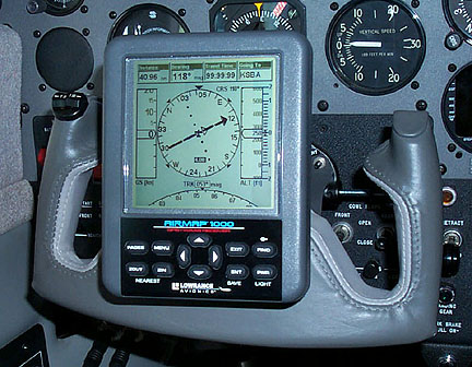
Lowrance does not display a turn-coordinator on any
page within the 1000. Lowrance's
feeling is and I quote 'We didn't put in a rate of turn indicator as
a GPS is not a gyro device and we feel the turn rate indicator does not
always depict aircraft attitude as on the Garmin 196'.
The company went on to say 'A momentary loss of GPS signal
could cause significant errors as well'.
'We instead give the expanded compass radius that immediately
reveals any rate of turn giving you the same information without the
implication of a gyro device'. I
disagree, I found the TC within the Garmin 196 was very helpful if
everything on the aircraft instrument panel went out. In fact, I few an aircraft using only the 196 for well over
an hour; the built-in TC was of real value to me.
I was able to keep the aircraft flying using only the AirMap 1000
but it was much harder than with the Garmin 196.
I wish they had installed the TC feature in this product.
My 'guess' there may be some product liability issues they
didn't want to deal with. I was rather surprised that Garmin displayed a TC on their
unit even though it 'appears' to operate fine.
Maybe a better pilot than myself wouldn't struggle as much
using only the 1000. Who knows? Another
issue I had with the unit was the VSI tape at the far right. At times it was hard to read due to the dark color and I
often had to think about what VSI rate it was showing.
The other tapes and windows just jump out at you but not the VSI;
this didn't help any when using only the AirMap 1000 for sole means of
keeping the aircraft flying bottom down.
It's a WAAS GPS.
Recently I made an automotive trip using the AirMap 1000. Twice
on my trip I stopped at a 'surveyed' marker that showed the exact
altitude of that marker. At
one marker the AirMap 1000 was four feet off and the other it displayed
between 4 and 6 feet of error. That's
right, single digit errors were verified, now that's accurate!
The automotive features of this unit are OK.
The unit has a good base map installed and unless you want detail
of an area, that's all you'll need.
Be advised the automotive Basemap has practically no coverage in
Canada or Mexico. The
supplied detail CD only covers the Continental USA, thus our Canadian
friends will lose out in the automotive world using this product
(aviation is fully covered in Canada).
The supplied CD contains millions of what is called 'Points of
Interest'. Banks,
ATM's, restaurants, gas stations and just about anything you can
imagine is contained within the supplied CD (prisons, brothels, shooting
ranges are not included on the CD).
The supplied flash memory card will hold a lot of data but I'd
strongly recommend getting another card to store your automotive
waypoints. The flash
memory cards can be purchased just about anywhere, no longer to you have
to purchase an expensive 'aviation' part.
 The Lowrance AirMap 1000 does not provide any 'turn-by-turn'
data. My problem using the
1000 in the automotive mode was 'Where the heck do you place the
thing'? Remember, it's huge! The
supplied suction cup mount will not stay on a rounded or rough surface.
In fact, I could only get the suction cup mount to stay put for a
few minutes on a flat piece of smooth glass.
I finally placed the unit near the gearshift console and used the
external antenna; then everything fell in place.
No doubt the AirMap 1000 is a good automotive GPS but its claim
to glory is in the airplane in my opinion.
There's no way this small product 'Review' could mention
all the nice aviation and automotive features of the 1000, you'll
constantly be amazed at all the little features you keep popping up.
The Lowrance AirMap 1000 does not provide any 'turn-by-turn'
data. My problem using the
1000 in the automotive mode was 'Where the heck do you place the
thing'? Remember, it's huge! The
supplied suction cup mount will not stay on a rounded or rough surface.
In fact, I could only get the suction cup mount to stay put for a
few minutes on a flat piece of smooth glass.
I finally placed the unit near the gearshift console and used the
external antenna; then everything fell in place.
No doubt the AirMap 1000 is a good automotive GPS but its claim
to glory is in the airplane in my opinion.
There's no way this small product 'Review' could mention
all the nice aviation and automotive features of the 1000, you'll
constantly be amazed at all the little features you keep popping up.
With over 2,000 miles of flying and driving behind
the AirMap 1000, I'm glad to report I love the darn thing. The
1000 isn't the best automotive unit in the world but it's an excellent
aviation unit and probably the best unit available within it's price
range. It's huge, easy to read and the simplest unit known to man
to operate. Years
back, Lowrance aviation products left some to be desired but the recent
AirMap 500 and now the monster size AirMap1000 clearly shows Lowrance is
a serious competitor in the portable GPS aviation market.
The company now produces aviation products that are designed by
pilots for pilots and believe me, you'll feel like the 1000 is a 10K
hour co-pilot with you on every flight.
In my opinion, the Lowrance AirMap 1000 is 'Product of the
Year' material. Try one,
I think you'll agree.