new and used avionics
 Sell Your Avionics Here
|
Avionics List
new and used avionics |
Sell Your Avionics Here
|
Buying Safety Tips |
Avionics Articles and Reviews
|
In the past I wouldn't recommend
aircraft owners purchasing a high priced Mode S transponder because of
the cost and virtually no benefit.
Sure, large aircraft need Mode S transponder to satisfy the
requirements for some TCAS but not so with part 91 operators.
In fact, there are some downsides to Mode S and that being the
'Big Brother' issue. You
see, anytime you are operating within Mode S coverage, ATC knows a lot
about the aircraft regardless if you are talking to ATC or not.
We program the Mode S transponder to place information such as
tail number, altitude and airspeed during the set up of the GTX 330 or
any other Mode S transponder. The
data mentioned above could be helpful for ATC, especially if they
aren't talking to you. Personally though, I think the benefits the Garmin GTX 330
transponder offers far exceed the few negatives.
Before I go any further, lets
go over a few terms so we are all on the same page.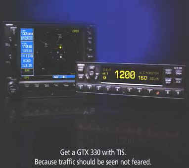 First is TCAS, this stands for Traffic Alert & Collision
Avoidance System. Another
term often heard and used is TAS, which stands for Traffic Advisory
System and then there's TCAD, which is Traffic & Collision Alert
Device. The Garmin GTX 330
uses TIS 'Traffic Information Service' which is sent up via ATC on
the Mode S data link, if coverage is available.
First is TCAS, this stands for Traffic Alert & Collision
Avoidance System. Another
term often heard and used is TAS, which stands for Traffic Advisory
System and then there's TCAD, which is Traffic & Collision Alert
Device. The Garmin GTX 330
uses TIS 'Traffic Information Service' which is sent up via ATC on
the Mode S data link, if coverage is available.
What's the difference between
systems such as the Goodrich SkyWatch and Ryan 9900BX and the GTX
330 you ask? The Goodrich and Ryan use what we call an active system.
These systems actually interrogate other aircraft transponders
and receive the reply from aircraft in the area and then that target is
shown on some type of a display. Goodrich and Ryan need not be in radar coverage areas to
operate. These systems have
several Modes of operation and are updated about every .5 (one-half)
second. The GTX 330 uses
TIS, which could be several seconds old and must be in a terminal Mode S
coverage area to provide any traffic information what so ever. The
Goodrich system lists for $17,980.00 without a display and the GTX 330
transponder lists for $4,995.00! I'll bet that got your attention!
Installation of the SkyWatch or 9900BX runs around 60 hours but
the Garmin GTX 330 can be installed in 8-12 hours normally. No doubt the
SkyWatch and 9900BX do more and work just about everywhere but there's
a price to pay for that kind of performance and that price is beyond the
range most general aviation aircraft owners.
I've flown dozens of hours behind the SkyWatch and to some
extent the 9900BX; and no doubt these systems can and do save lives.
Their performance is excellent.
The Garmin GTX 330 Mode S
transponder is also your standard Mode A/C transponder but with a
data link to ATC. This data link has the capability to send data up to the
aircraft as well as receive data from the aircraft.
With Mode S, ATC can send information directly to one aircraft,
which is the main advantage of Mode S.
Mode S is in its pioneer stage, expect to see a lot more from
this system in the future.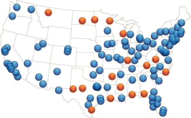 There's
no reason your aircraft couldn't receive primary targets, weather and
other data in the future via Mode S. Presently there are around 120 Mode
S radar sites in the USA and each site has a range of 55-60 miles. This
range will be doubled this year according to one FAA person I talked to.
I was also told that due to the fact
that Mode S is getting popular (mainly due to the GTX 330) one
would expect the FAA to install more Mode S sites in the future. The GTX
330 operates much like any other transponder; press 'On', 'ALT',
'STBY' or 'OFF' are the Modes of operation, just like most GA
transponders. To enter a
squawk code, simply press the buttons on the bottom of the unit. If ATC gives you the code of '4521', simply press the
'4521' button; that's all there is to it.
Once you are given the words 'Squawk 1200', press the
'VFR' button and the transponder automatically changes the code to
'1200'. There's a little light that reads 'R' on the display
that flashes whenever your transponder is replying to ATC
interrogations.
There's
no reason your aircraft couldn't receive primary targets, weather and
other data in the future via Mode S. Presently there are around 120 Mode
S radar sites in the USA and each site has a range of 55-60 miles. This
range will be doubled this year according to one FAA person I talked to.
I was also told that due to the fact
that Mode S is getting popular (mainly due to the GTX 330) one
would expect the FAA to install more Mode S sites in the future. The GTX
330 operates much like any other transponder; press 'On', 'ALT',
'STBY' or 'OFF' are the Modes of operation, just like most GA
transponders. To enter a
squawk code, simply press the buttons on the bottom of the unit. If ATC gives you the code of '4521', simply press the
'4521' button; that's all there is to it.
Once you are given the words 'Squawk 1200', press the
'VFR' button and the transponder automatically changes the code to
'1200'. There's a little light that reads 'R' on the display
that flashes whenever your transponder is replying to ATC
interrogations.
The GTX 330 is easy to operate but
it has a lot of nice, built-in features.
If you are into timers, then this transponder will really excite
you. The 'Flight Timer' is a neat feature. This timer will start anytime you press 'Start' or if
tied to GPS, will start automatically the timer once airborne and stop
once you land. This timer
keeps the time until you reset it, making it an excellent device to time
trips. It does NOT reset
after shutdown, reset is made via the pilot pushing a button.
Older transponders reset after the avionics was turned off,
finally Garmin let us decide when to reset the Operation Timer; you'll
use it often. Of course
there's a count up and a count down timer built-in the GTX 330.
OAT/DALT can be displayed on the GTX 330 provided you have an
optional temperature input probe or air data computer.
A temperature cannot be inserted, thus without a temperature
input, this page does nothing.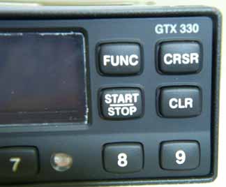 Of
course, you can insert a temperature in your 400/500 series Garmin and
get the density altitude should you desire.
PRESSURE ALTITUDE can be displayed on the transponder in feet or
meters, depending on the configuration and encoder input. Included is an
altitude 'Trend Indicator' that shows an arrow to the right of the
Pressure Altitude' indicating if the aircraft is climbing or
descending; for some reason, I've always been able to figure out if
the aircraft was going up or down. But if I now get confused the GTX 330 will tell me if my
altitude is decreasing or increasing.
The ALTITUDE MONITOR is another neat feature.
Settle in the altitude you wish to be at, activate the monitor
and when you exceed that altitude by some amount determined by you; a
voice alarm and warning annunciator will give you a warning that
you've exceed your set altitude.
Of course I would never need such a feature but some of you
may'
Of
course, you can insert a temperature in your 400/500 series Garmin and
get the density altitude should you desire.
PRESSURE ALTITUDE can be displayed on the transponder in feet or
meters, depending on the configuration and encoder input. Included is an
altitude 'Trend Indicator' that shows an arrow to the right of the
Pressure Altitude' indicating if the aircraft is climbing or
descending; for some reason, I've always been able to figure out if
the aircraft was going up or down. But if I now get confused the GTX 330 will tell me if my
altitude is decreasing or increasing.
The ALTITUDE MONITOR is another neat feature.
Settle in the altitude you wish to be at, activate the monitor
and when you exceed that altitude by some amount determined by you; a
voice alarm and warning annunciator will give you a warning that
you've exceed your set altitude.
Of course I would never need such a feature but some of you
may'
The GTX 330 has several Audio Alerts: Expect more as time goes on.
' "Leaving Altitude" Translates into "You just busted your altitude".
' "Traffic" TIS traffic alert is received.
' "Traffic Not Available" TIS service is not available or out of range.
' "Timer Expired" Countdown timer has run out.
The above features are nice and add a lot of value
to the GTX 330 but the Crown Jewel of this Mode S transponder is its
ability to receive "Traffic Information Service (TIS)".
Traffic Information Service (TIS) provides a graphic display of
traffic advisory information in the cockpit for non-TCAS equipped
aircraft. TIS is a ground-based service providing relative location of
ATCRBS Mode A and Mode C transponder equipped aircraft with a specified
service area. 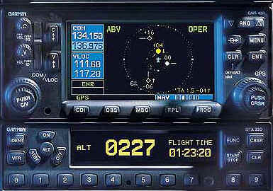 The TIS ground sensor uses real time track reports to
generate traffic notification. The GTX 330 uses this data. TIS Traffic
data is sent up by the ground station to the GTX 330 and can be
displayed on the Garmin 400/500 GPS. All aircraft that show up as
secondary targets on the ground radar should show up on the Garmin
display if they are with the TIS Coverage Volume. The GTX 330 does
not display primary targets (skin reflections). The GTX 330 has the
capability to display primary radar targets but the FAA software isn't
current enough to allow the data to be placed on the Mode S data link.
That will change over a period of time. Aircraft operating without a
transponder or a transponder that isn't correctly aligned will not be
seen by ATC nor displayed on the Garmin display.
The TIS ground sensor uses real time track reports to
generate traffic notification. The GTX 330 uses this data. TIS Traffic
data is sent up by the ground station to the GTX 330 and can be
displayed on the Garmin 400/500 GPS. All aircraft that show up as
secondary targets on the ground radar should show up on the Garmin
display if they are with the TIS Coverage Volume. The GTX 330 does
not display primary targets (skin reflections). The GTX 330 has the
capability to display primary radar targets but the FAA software isn't
current enough to allow the data to be placed on the Mode S data link.
That will change over a period of time. Aircraft operating without a
transponder or a transponder that isn't correctly aligned will not be
seen by ATC nor displayed on the Garmin display.
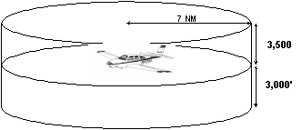
Your Garmin 400/500 GPS will display up to eight traffic target with a 7.5 mile radius of your aircraft; 3.000ft below your aircraft and 3,500ft above your aircraft. Again, you MUST be operating in an area that supports Mode S operations, there are around 120 in the USA at the present but I'd be willing to bet more will come on line soon.
While Garmin is VERY CLEAR to state that TIS is NOT intended to be used as a collision avoidance device; it does offer a lot of capability when in a Mode S coverage area. I'll be the first to say that TIS coverage isn't as good as a true TCAD such as the SkyWatch or Ryan TCAD but the GTX 330 doesn't cost $19,000 either (plus labor). In my opinion, anyone owning a Garmin 400/500 series GPS should put the GTX 330 on top of the "Must Have" list.
Test Equipment. Many avionics shops do not have
the proper Mode S test equipment to install the GTX 330. As called out
in FAR 91.413, Mode S must be tested after installation. 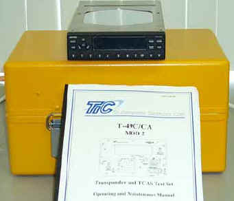 The required
test equipment is VERY expensive. Chances are you'll have to pay more
in the future for your 91.413 transponder test due to the extra time
required to test the transponder along with the equipment needed to
accomplish the test.
The Mode S test box is needed to aid in programming the Mode S
transponder during installation. In other words, you can't just wire
one of these jewels into the aircraft; a Garmin dealer must program it.
The required
test equipment is VERY expensive. Chances are you'll have to pay more
in the future for your 91.413 transponder test due to the extra time
required to test the transponder along with the equipment needed to
accomplish the test.
The Mode S test box is needed to aid in programming the Mode S
transponder during installation. In other words, you can't just wire
one of these jewels into the aircraft; a Garmin dealer must program it.
The Installation even though the GTX 330 will fit in the rack of the popular Garmin GTX 327, the connector and back shell are different. There will also be some additional wiring from this transponder to the audio panel and 400/500 series Garmin GPS. The audio out will work with just about any audio panel that has what we call "Aux" inputs. Popular audio panels such as the Garmin GMA 340 and PS-Engineering panels will work fine with this system. The connector that is attached to the older GTX 327 transponder does not have enough pins to supply outputs to the audio panel and 400/500 series GPS, thus a larger connector was needed. In my opinion, Garmin made an error with this new connector. The older GTX 327 transponder had male pins installed on the box, thus the connector in the aircraft had female pins, like most Modern avionics do. Did Garmin carry this fine logic over to the GTX 330? No, some engineer at Garmin decided it was better to have the male pins sticking out in the rack. Now here's why I don't like male pins in the radio rack. Let's say you have a transponder problem down the road and the transponder is removed while you are using an ohmmeter to read out the wiring. There's a good chance you'll slip off the power wire and cause a short, which will either mess up the pin or apply power to a pin that wasn't ever intended to have power applied. With female pins, you simply place the meter probe in the hole. I'd like to see the engineer who decided to use male pins in the rack stand on his/her head in July at Los Vegas NV and troubleshoot the wiring in a Cessna 421. Sure, there are times male pins must be used in the radio rack but the GTX 330 isn't one of them. You may be able to tell I'm not happy with the connector Garmin picked but it is legal and we have to use it. Now I'll get off my soapbox.
Now lets discuss the TIS 'Traffic Information
System' portion of
this unit. As you probably
already know, you need a Garmin 400/500 series GPS to display the
traffic information on. To
date traffic information from the GTX 330 can not be displayed on any
other MFD and I doubt you'll ever see it displayed on other MFD's
such as the UPSAT MX20 or Sandel EHSI.
 Again remember, if an aircraft does NOT have a properly
working and aligned transponder, it will be invisible to ATC and will
not be available for TIS. TIS
receivers such as the GTX 330, display up to eight traffic targets with
7.5 nautical miles from 3,000 below to 3,500 feet above the requesting
aircraft. Unlike the SkyWatch you can't have the TIS look up, down or
unrestricted. Range can be
changed on the Garmin 400/500 MFD simply by expanding or compressing the
'Range' key. I found I
often would change ranges during flight to get an accurate idea how
close the aircraft was to me. The
400/500 series Garmin MFD must be configured to accept data from GTX 330
and a 'Traffic Page' is added to the 'Nav' pages.
Traffic is shown of the normal nav pages in conjunction with
whatever map you may have on the screen or you can view just the traffic
on the Traffic only page. TIS symbology is the same that is used by TCAS.
A 'Traffic Advisory' (TA) symbol appears as a solid yellow
dot. All other traffic is
displayed as a hollow white diamond.
The altitude difference between your aircraft and other aircraft
is displayed either above or below the symbol.
If the symbol is above your aircraft, then this altitude data
will be place above the symbol. If
the symbol is below your aircraft, then the altitude data is placed
below the symbol making it easy to see the complete picture at a glance.
Altitude trend is displayed as an up arrow (+500 ft/min), down
(-500 ft/min), or no altitude symbol if the rates are less than those
stated.
Again remember, if an aircraft does NOT have a properly
working and aligned transponder, it will be invisible to ATC and will
not be available for TIS. TIS
receivers such as the GTX 330, display up to eight traffic targets with
7.5 nautical miles from 3,000 below to 3,500 feet above the requesting
aircraft. Unlike the SkyWatch you can't have the TIS look up, down or
unrestricted. Range can be
changed on the Garmin 400/500 MFD simply by expanding or compressing the
'Range' key. I found I
often would change ranges during flight to get an accurate idea how
close the aircraft was to me. The
400/500 series Garmin MFD must be configured to accept data from GTX 330
and a 'Traffic Page' is added to the 'Nav' pages.
Traffic is shown of the normal nav pages in conjunction with
whatever map you may have on the screen or you can view just the traffic
on the Traffic only page. TIS symbology is the same that is used by TCAS.
A 'Traffic Advisory' (TA) symbol appears as a solid yellow
dot. All other traffic is
displayed as a hollow white diamond.
The altitude difference between your aircraft and other aircraft
is displayed either above or below the symbol.
If the symbol is above your aircraft, then this altitude data
will be place above the symbol. If
the symbol is below your aircraft, then the altitude data is placed
below the symbol making it easy to see the complete picture at a glance.
Altitude trend is displayed as an up arrow (+500 ft/min), down
(-500 ft/min), or no altitude symbol if the rates are less than those
stated.
The Target Track Vector is a feature that even
the Multi-thousand dollar TCAD and TAS don't offer.
This Modern marvel places what I call a vector line near the
symbol showing the general direction the aircraft is flying.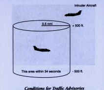 Simply by
glancing at the Garmin MFD, you instantly get a picture that will
determine if the traffic is going to be a threat or not.
Normally with a SkyWatch or the Ryan you have to monitor the
traffic for some period of time to figure out if the targets are going
to be a threat to your aircraft, not so with the Garmin GTX 330.
It showed me in seconds what often took 10-15 seconds to figure
out using other systems such as the Ryan 9900BX.
You'll be amazed at how much data the Garmin TIS gives and how
seldom you'll need to study the situation due to the vector lines. In
order to get a "real" Traffic Advisory, the intruder aircraft
must approach your aircraft on a course that will intercept (defined by
a .5 horizontal radius and a relative altitude of +/- 500 ft) your
course within 34 seconds. Believe, me, that 34 seconds goes by
fast when you get an alert and can't see the blasted intruder
aircraft! Keep looking, rest assured it's coming your
way.
Simply by
glancing at the Garmin MFD, you instantly get a picture that will
determine if the traffic is going to be a threat or not.
Normally with a SkyWatch or the Ryan you have to monitor the
traffic for some period of time to figure out if the targets are going
to be a threat to your aircraft, not so with the Garmin GTX 330.
It showed me in seconds what often took 10-15 seconds to figure
out using other systems such as the Ryan 9900BX.
You'll be amazed at how much data the Garmin TIS gives and how
seldom you'll need to study the situation due to the vector lines. In
order to get a "real" Traffic Advisory, the intruder aircraft
must approach your aircraft on a course that will intercept (defined by
a .5 horizontal radius and a relative altitude of +/- 500 ft) your
course within 34 seconds. Believe, me, that 34 seconds goes by
fast when you get an alert and can't see the blasted intruder
aircraft! Keep looking, rest assured it's coming your
way.
Lets talk about TIS Traffic Display Status, Pilot Response and some other boring things before flying. Below are some items you may see on your Garmin MFD.
' STBY-when the Garmin MFD displays STBY in the upper right corner of the display the TIS system is in the Standby Mode, duh'
' OPER-when the Garmin MFD displays OPER in the upper right corner of the display, the TIS system is operational and available to display traffic on the Nav Map page or separate Traffic page.
' AGE-if traffic is not refreshed within 6 seconds; an age indicator is displayed in the lower right corner of the MFD (when displaying traffic). After another 6 seconds if data is still not received, the traffic is removed from the display.
' TRFC CST- this banner is located above the AGE timer indicates that displayed traffic is held even though the data is stale.
' TRFC RMVD- this banner indicates that traffic has been removed from the MFD due to age of the data being too old to 'coast' (for the time period of 12-60 seconds fro the last receipt of a TIS message).
' UNAVAIL- when a period of 60 seconds elapses with no data, TIS is considered to be unavailable. This message is displayed on the MFD.
' NO DATA-means no data is being received from the transponder. Chances are you forgot to turn on the transponder.
' DATA FAIL-is displayed when data is being received from the GTX 330 transponder but there was a failure detected in the data.
'
FAILED-means there's a problem within the GTX
330.
What's it like to fly with the GTX 330?
We've installed several of these transponders and now
after flying one for sometime, I feel experienced enough to write about
my findings. Mode S coverage is not available at our home here in Santa
Maria CA (SMX), thus some flying out of the general area had to be done
to verify these units worked as advertised.
Yes, I had to fly other folk's aircraft, use their fuel and
play with some of the best avionics in the world; yes it's a tough job
but someone has to do it' According to the Mode S coverage charts, the nearest covered
area was about 40 miles south of SMX and that being Santa Barbara CA.
Sure enough, within 10 miles of Santa Barbara (SBA) I got an
audio alert through the headset that said 'Traffic Available' and
symbols started showing up on the Map page and the Traffic page also.
I was very impressed to say the least; my Garmin 530 showed five
targets within three miles of me and within one minute, I had visually
verified three of the targets.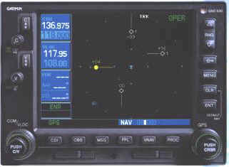 The
vector line with the target aircraft symbol was a huge help in
determining if the aircraft is a target I should watch, or not.
One target in particular was ahead of me about 1.5 miles and
1,100ft below my aircraft. I
started a climb to see if the altitude related to that symbol would
change and sure enough, within a few seconds the altitude showed him
1,800ft below me. A few
minutes later I gave a call to Approach and asked if they could point
out any traffic in my area and advised them I was checking out a Mode S
system. Fortunately approach control was having a slow day and gave
me a code and soon gave me the position and altitude of all the aircraft
within three miles of me. Even
though I could only see two of the targets called out by Approach my
Garmin MFD displayed each and everyone, their correct position and the
correct altitude. For the
record, each aircraft Approach and Center called out to me during this
three-hour test was verified by the Garmin MFD and/or visually.
In other words, the GTX 330 data to the MFD was 100%.
If ATC saw the traffic, then my Garmin MFD displayed it also;
even though at times I couldn't visually verify the target (I can't
see several miles out). I've
flown this system several times sense this evaluation
in the busy Los Angeles airspace and found it to be a godsend.
If ATC radar is seeing the secondary return of the aircraft and
TIS is up and working; then the Garmin GTX 330 Mode S transponder will
display the traffic on the Garmin 400/500 series display.
Keep in mind that primary targets (skin reflections) are not
part of TIS at this time, thus not displayed on the Garmin display.
I've flown dozens of hours using the SkyWatch and Ryan systems
and indeed they do have some advantage over the TIS due to the fact they
operate in non-Mode S coverage areas, which covers most of the USA.
Yes, I did find some errors with the GTX 330. Bearing from the aircraft may not be exact due to crab angles
and turning errors. In
other words, if the display shows traffic at 3 o'clock, you may see
the traffic at 2 o'clock due to the crab angle you are flying. This
problem would not be apparent in a SkyWatch or Ryan due to the fact they
will accept heading inputs, the GTX 330 does not accept heading inputs
offered in most GA aircraft. Another anomoly I found was this. Fly the aircraft straight and level at a speed of 200 knots,
then roll 90 degrees and pull about 4 G's.
Within 12 seconds you'll get'Traffic' audio warning and a
scary yellow dot on the Garmin indicator showing traffic exactly where
you are. What happened is
the aircraft is in such a tight turn that the time difference between
radar sweeps makes the system think you are on a collision course with
yourself. Once this my
Garmin display gave me a 'TRAFFIC' warning after I took off from an
airport and made a sharp right turn after take off.
This airport had Mode S coverage all the way to the ground, thus
my sharp turned confused the system. I would imagine if you practiced
steep turns in the same area for a period of time, you would get the
same results. Neither of the above issues are anything to be concerned
about. Let me say
this. With exception to the
crab angle issue and extreme sharp turns as mentioned above; if you are
operating in Mode S coverage area, receiving TIS from the ground, the
GTX 330 data that is displayed on the Garmin 400/500 series radio is
just as accurate as the data on the high priced TCAD and TAS systems
mentioned above but at a fraction of the cost.
If you fly in high traffic areas that are supported by Mode S
coverage, then the GTX 330 is an excellent alternative to the active
TCAD and TAS systems.
The
vector line with the target aircraft symbol was a huge help in
determining if the aircraft is a target I should watch, or not.
One target in particular was ahead of me about 1.5 miles and
1,100ft below my aircraft. I
started a climb to see if the altitude related to that symbol would
change and sure enough, within a few seconds the altitude showed him
1,800ft below me. A few
minutes later I gave a call to Approach and asked if they could point
out any traffic in my area and advised them I was checking out a Mode S
system. Fortunately approach control was having a slow day and gave
me a code and soon gave me the position and altitude of all the aircraft
within three miles of me. Even
though I could only see two of the targets called out by Approach my
Garmin MFD displayed each and everyone, their correct position and the
correct altitude. For the
record, each aircraft Approach and Center called out to me during this
three-hour test was verified by the Garmin MFD and/or visually.
In other words, the GTX 330 data to the MFD was 100%.
If ATC saw the traffic, then my Garmin MFD displayed it also;
even though at times I couldn't visually verify the target (I can't
see several miles out). I've
flown this system several times sense this evaluation
in the busy Los Angeles airspace and found it to be a godsend.
If ATC radar is seeing the secondary return of the aircraft and
TIS is up and working; then the Garmin GTX 330 Mode S transponder will
display the traffic on the Garmin 400/500 series display.
Keep in mind that primary targets (skin reflections) are not
part of TIS at this time, thus not displayed on the Garmin display.
I've flown dozens of hours using the SkyWatch and Ryan systems
and indeed they do have some advantage over the TIS due to the fact they
operate in non-Mode S coverage areas, which covers most of the USA.
Yes, I did find some errors with the GTX 330. Bearing from the aircraft may not be exact due to crab angles
and turning errors. In
other words, if the display shows traffic at 3 o'clock, you may see
the traffic at 2 o'clock due to the crab angle you are flying. This
problem would not be apparent in a SkyWatch or Ryan due to the fact they
will accept heading inputs, the GTX 330 does not accept heading inputs
offered in most GA aircraft. Another anomoly I found was this. Fly the aircraft straight and level at a speed of 200 knots,
then roll 90 degrees and pull about 4 G's.
Within 12 seconds you'll get'Traffic' audio warning and a
scary yellow dot on the Garmin indicator showing traffic exactly where
you are. What happened is
the aircraft is in such a tight turn that the time difference between
radar sweeps makes the system think you are on a collision course with
yourself. Once this my
Garmin display gave me a 'TRAFFIC' warning after I took off from an
airport and made a sharp right turn after take off.
This airport had Mode S coverage all the way to the ground, thus
my sharp turned confused the system. I would imagine if you practiced
steep turns in the same area for a period of time, you would get the
same results. Neither of the above issues are anything to be concerned
about. Let me say
this. With exception to the
crab angle issue and extreme sharp turns as mentioned above; if you are
operating in Mode S coverage area, receiving TIS from the ground, the
GTX 330 data that is displayed on the Garmin 400/500 series radio is
just as accurate as the data on the high priced TCAD and TAS systems
mentioned above but at a fraction of the cost.
If you fly in high traffic areas that are supported by Mode S
coverage, then the GTX 330 is an excellent alternative to the active
TCAD and TAS systems.
More About TIS. While TIS has been in service for sometime now, few people know anything about it. While the FAA says contact Flight Service for problems, every person that I talked to thought I was from a different planet when I mentioned TIS. I finally found a number to call if you suspect a failure in the TIS system and that is 866-432-2622. Well, I called this number and a real human answers the phone! I started talking to the gentleman about a suspected problem with TIS and he stopped me and asked, 'What is TIS'? After some discussion he was going to talk to the 'head engineer' about this system during their next meeting. Be advised NOTAM's do not cover outages of TIS. If you are operating in a Mode S terminal area and not receiving traffic, chances are TIS is down in that area and there's no way to verify it or know when it will be up and running again. A friend of mine found TIS was out over a week in his local area (San Diego CA) but yet Mode S coverage was still available. Expect more nice goodies to be added to the TIS system as time goes. Also be aware, TIS presently is only available on selected terminal radars at this time but rest assured as this system becomes more popular (and it will) enroute systems will employee TIS also; it's the wave of the future. Here's a link to a FAA Draft that really covers TIS and how it operates; I'd strongly advise you read it. The above talks about predictive algorithms and gives you a good detail about how the TIS system works.
After flying with several GTX 330's for a month,
I'm convinced this is a must have product; it works great and could be
a real bacon saver. 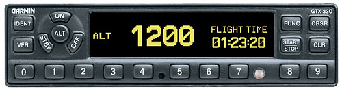 If you
presently own a Garmin 400/500 series panel-mount, then all you need it
the GTX 330 transponder and presto, 'You've got Traffic'.
My experience with the GTX 330 was excellent and the benefit to
cost ratio is probably the best thing out there at this time.
Will more data be available on the TIS data stream in the future
you ask? Sure, expect
weather, primary aircraft targets and much more; it's only a matter of
time. Of course when that time comes, the GTX 330 will be able to
handle the additional benefits with just a mere software change.
If you
presently own a Garmin 400/500 series panel-mount, then all you need it
the GTX 330 transponder and presto, 'You've got Traffic'.
My experience with the GTX 330 was excellent and the benefit to
cost ratio is probably the best thing out there at this time.
Will more data be available on the TIS data stream in the future
you ask? Sure, expect
weather, primary aircraft targets and much more; it's only a matter of
time. Of course when that time comes, the GTX 330 will be able to
handle the additional benefits with just a mere software change.
The GTX 330 is a product that exceeded my expectations and is built with the future in mind and in my opinion, cost effective. When operating in an area of coverage, the GTX 330 traffic display was just as accurate as any of the high dollar TCAD's but at a fraction of the cost. To sum up my thoughts on the GTX 330; I'll just say Garmin hit one over the fence when they came out with the GTX 330. This box is definitely 'Product of the Year' material.